
Little Annapurna Hike - Everything You Need to Know
- Emma H. Baldwin
- Aug 15, 2022
- 7 min read
Updated: Jan 9, 2023
Hiking Little Annapurna in the Enchantments is a steep and long endeavor that rewards climbers with incredible views from one of the tallest mountains in Washington.
Although it may not look it, Little Annapurna is one of the 100 tallest mountains in Washington. It ranks at #68 on the famous Bulger list and is a staple of The Enchantments and the Stuart Range. It's less impressive than its neighbors, Colchuck Peak and Dragontail Peak, but its moderately steep slopes and unique profile make it an enviable climb.

The Little Annapurna Trail is one of Traverse the Pacific Northwest's Top 12 Best Hikes Near Leavenworth. Have you done them all yet? Let us know what you think of this one below.
How to Get to the Little Annapurna Trailhead
The Little Annapurna trail starts at the Stuart Lake Trailhead, just 25 minutes from Leavenworth. If you're coming from Wenatchee, it'll take about an hour to get there. From Seattle, you can expect a commute of just over two hours.
The Stuart Lake Trailhead
The Stuart Lake trailhead is an incredibly popular place, despite its extreme remoteness and poorly maintained access road. It's deep in the Alpine Lakes Wilderness and is only accessed via Forest Service Road 7601, sometimes as FS road #7601 or as Mountaineer's Creek Road.
To get to the beginning of FS road #7601, you'll need to drive down Icicle Creek Road, headed away from Leavenworth, for about 18-20 minutes. It's around 9.4 miles from downtown Leavenworth. The turn for FS road #7601 comes up quickly, so keep an eye out for the sign on the right-hand side of the road. The turn will be on your left, and you'll pass by Bridge Creek Campground on your way up the increasingly-poor gravel road.

Stuart Lake Trailhead Permit
You'll be required to have a Northwest Forest Pass to park at the trailhead. If you don't have one ready, there is a trailhead sign with day-pass parking slips you can fill out. The closest spot to get a day parking pass is at the far end of the parking lot, right at the beginning of the trail.
Make sure to fill one of these slips out, leave the requisite portion on your dashboard, and submit the envelope into the box with your $5 before starting the trail. They do ticket here and know how popular the trail is.
Northwest Forest Passes are $30 for the year if you want to buy one beforehand.
Did You Know? The trail to Colchuck Lake runs along Mountaineer's Creek.
Little Annapurna Trail Facts
The Little Annapurna trail is a 16-mile roundtrip, an out-and-back hike that challenges hikers with its long approach, incredibly steep climb up Asgard Pass, and sometimes problematic snow conditions. This hike is only for your experienced hikers and mountaineers.
Distance | Elevation Gain | Time Required | Difficulty |
|---|---|---|---|
16 miles | ~6,000 feet | 11 hours | 8/10 |
You should only attempt to climb little Annapurna if you have the requisite experience with steep snow and off-trail route-finding; you should also be aware that trails like the Little Annapurna hike are deceptive in their statistics. This means that although the hike is 16 miles, it may take you as long or longer than as a 20+ mile day.
Did you know? Little Annapurna sits at an elevation of 8,440.'
Most hikers in the Leavenworth area and in Washington more generally will already know about the hike to Colchuck Lake. It's one of the most famous trails in the state and is enjoyed by visitors from around the country throughout spring, summer, and fall.
It’s well worth taking the time to appreciate this spectacular lake as you weave around it and climb high above it to Asgard Pass.
We made a complete Colchuck Lake Visitor's Guide for you to walk you through this hike specifically. Make sure to check it out for more information!
Little Annapurna Hike Details
Start your day at the Stuart Lake trailhead (keep reading for what it's like to hike in from Snowlakes).
Make sure you have your parking pass in place and that you haven't parked in one of the reserved spots for the lucky few chosen in the Enchantments lottery for camping spots. Head down the parking lot to the far end, where most cars are parked.
The trail dives into the woods, starting out relatively flat with a few uphill sections. For 1.5 miles, you'll wander along the creek (don't wander too much as you have a huge day ahead of you). Cross a lovely wooden bridge and prepare yourself for some elevation gain.

The trail ascends rocky switchbacks before meeting a junction. You can go right for Stuart Lake and left for Colchuck Lake. Take a veering left and cross a log bridge while enjoying the outrageously beautiful trees and peaks around you.
After another bridge, stay right and cross a creek. The next uphill portion is very rocky, but if you take your time and enjoy the scenery along the way, it's not too bad!

Pro-tip: Don't go straight up through the boulder field! It's not the way. Stay low and avoid the biggest boulders.
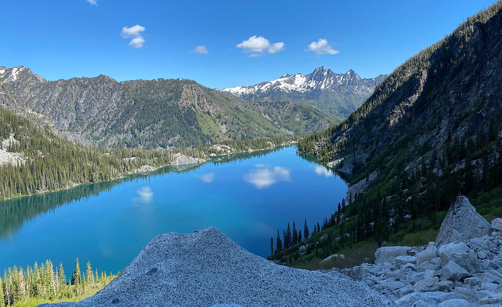
After 4.5 miles along the trail, you'll reach the first view of Colchuck Lake. This is a great place to take a break for a few minutes before making the walk around the right-hand side to get to the steep, rocky trail up to Asgard Pass and the main Enchantments area.
Hiking Asgard Pass in the Enchantments
The trail dips down and to the right slightly. YOu may lose it at this point but just keep in mind that you need to go right around the lake. As long as you head in that direction, you'll make it where you need to be.
The trail meets with a large boulder field. Above you and to the right is Colchuck Peak, and right next to Asgard Pass is Dragontail Peak. You want to go up the biggest gully that is on the left-hand side of Dragontail Peak.
Luckily, because the Enchantments hike is so popular, there are a number of cairns to help you find the best way through. The boulders are over fairly quickly, and you're into the meat of the hike up Asgard.

You want to climb on the LEFT side of Asgard Pass, not in the middle or on the right. This is particularly true if there is any snow. There is a waterfall that runs down the middle of the pass, making the snow there far more unstable than that to the left.
The trail is also beat in on the left side from 100s of people hiking up and down it yearly. There are also cairns on this side and far less rock fall. If you're at all confused about where to go, stay to the left, follow the cairns, and be on the lookout for other people. A lot of the time, this section of the trail has more than one group scattered along it.
You should be prepared for Asgard Pass to take 2 hours; despite the minimal distance, the elevation gain and the terrain is no joke. Towards the top of the pass, you'll need to traverse right across a snowfield (if it's there) to the trail on the other side. Again, be on the lookout for cairns. This marks the final section of the hike up Asgard, so keep your spirits up!
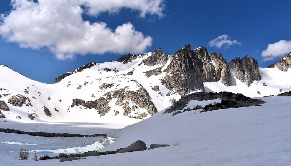
At the top of the pass, celebrate, and look diagonally to your right. Nearly straight ahead is Little Annapurna. The peak doesn't look like much from this side, especially if everything is covered in snow, but it's your goal!

To your right is Dragontail Peak, also a popular scramble route. In fact, many hikers choose to combine the two peaks on one hike because they are so close together. Between the two is another rocky outcropping known as the Witches Tower (8,250'). It divides the Snow Creek Glacier. On the traverse between the two mountains, many hikers scramble up the Tower to tick that off too! The scramble is on the south face.
From the top of the pass, follow the boot path through the stone or the cairns along the Enchantment's trail. The path wraps down between Isolation Lake (which will still be frozen in the early season) and Lake Reginleif or between Tranquil Lake and Lake Reginleif. The latter is the more popular route because the elevation is less. You'll pass through the Lake Olrun Backcountry Campsite and between Lake Olrun and Lake Sigrun, which will also likely be frozen.
About 0.6 miles from the top of the pass, the trail to Little Annapurna veers right, away from the main trail through the Enchantments. The turn-off is fairly obvious as it's at this point that you need to start heading towards your objective. It's also around now that you'll likely be moving away from any crowds you may have been hiking with on the way in.
Little Annapurna Climb
From the turn-off, you'll pass another likely frozen lake on your left while heading straight for the mountain. The trail steepens significantly here, and if there's snow, you're likely going to want to take out your ax; otherwise, from here, it's a fairly steep scramble but nothing too outrageously difficult.
The summit is at 8,458' and is one of the tallest mountains in Washington! Savor your position on the summit with only a few taller peaks, Dragontail and Colchuk, in view.
The next-closest peak, to your right, if you're looking back the way you came, is McClellan Peak. You'll also be able to see Prusik Peak's spire in the distance, as well as the mountains of Wenatchee National Forest, like Navaho Peak.
The descent is the same as the ascent unless you want to traverse over to Dragontail Peak and tick that off as well (although most hikers do the peaks in the opposite order because of elevation loss and gain).
Tips for Hiking Little Annapurna
A Northwest Forest Pass is the required permit for Little Annapurna, whether you park at the Snowlakes Trailhead or the Stuart Lakes Trailhead.
We recommend: Do not attempt this hike from the Snowlakes side of the Enchantments! If you do, you'll add nearly 10 miles to your day. Start at Stuart Lake!
Hustle in the beginning, slow down in the middle, and save your knees for the tough descent.
Comments